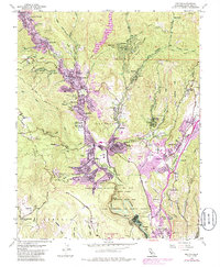
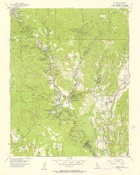
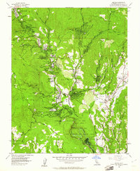
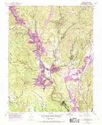
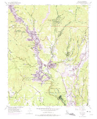
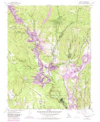
1955 Map of Felton
USGS Topo · Published 1986About this map
San Lorenzo River serves as the central artery for this portion of the Santa Cruz Mountains, where timber-harvesting history transitioned into a mid-century landscape of vacation camps and residential mountain communities. The valley floor is tightly packed with settlements like Ben Lomond, Glen Arbor, and Felton, each connected by the winding river and the Southern Pacific rail line. The presence of Henry Cowell Redwoods State Park and Mount Hermon indicates the region's early 20th-century evolution into a destination for spiritual retreats and nature preservation. To the east, Scotts Valley appears in its earlier form before significant suburban expansion, featuring the Skypark Airport and Camp Evers. High above the valley on Ben Lomond Mountain, the remote Bald Mountain School points to the isolated nature of the upland ridge communities during this era of California's coastal range development.
Find a feature on this map
71 named features on this map. Tap any name to fly to it.
Don’t see what you’re looking for? This feature index may not catch every label — zoom into the map to look around manually.
Map Details
Editions of this 1955 Felton Map
6 editions found
Other maps of this area

1902 · Santa Cruz
USGS Topo · 1:125,000

1912 · Capitola
USGS Topo · 1:62,500

1914 · Capitola
USGS Topo · 1:62,500

1916 · New Almaden
USGS Topo · 1:48,000

1919 · New Almaden
USGS Topo · 1:62,500
1940 · Capitola
USGS Topo · 1:62,500

1940 · Los Gatos
USGS Topo · 1:62,500

1943 · Los Gatos
USGS Topo · 1:62,500

1947 · San Francisco
USGS Topo · 1:250,000

1947 · San Jose
USGS Topo · 1:250,000