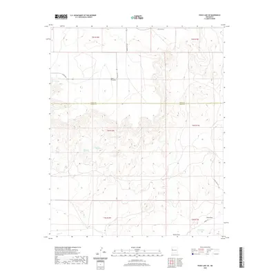
2020 Map of Fence Lake SW
USGS Topo · Published 2020About this map
Santa Rita Mesa dominates this high-altitude landscape along the border of Cibola and Catron counties, serving as a prominent topographic anchor in a region defined by its vital water sources. The map identifies several critical hydraulic features necessary for life in this arid environment, including Old Santa Rita Springs, New Santa Rita Springs, and Moreno Spring. These springs and seasonal drainages like Nations Draw and Tejana Draw reveal the essential network of watering points that historically supported cattle ranching and early homesteading. The local road system, including Moreno Hill Rd and Hubbell Rd, follows the natural contours of the mesas and draws, illustrating how human passage and settlement patterns were dictated by the availability of water at sites like Nicolas Spring and along Largo Cr.
Find a feature on this map
21 named features on this map. Tap any name to fly to it.
Don’t see what you’re looking for? This feature index may not catch every label — zoom into the map to look around manually.
Map Details
Editions of this 2020 Fence Lake SW Map
This is the sole edition of this map. No revisions or reprints were ever made.
Other maps of this area

1954 · Saint Johns
USGS Topo · 1:250,000

1957 · Saint Johns
USGS Topo · 1:250,000

1958 · Saint Johns
USGS Topo · 1:250,000

1962 · Saint Johns
USGS Topo · 1:250,000

1972 · Zuni Salt Lake
USGS Topo · 1:24,000

1972 · Lake Armijo
USGS Topo · 1:24,000

1972 · Fence Lake
USGS Topo · 1:24,000

1972 · Tejana Mesa
USGS Topo · 1:24,000
1972 · Cerro Prieto
USGS Topo · 1:24,000

1972 · Fence Lake SW
USGS Topo · 1:24,000