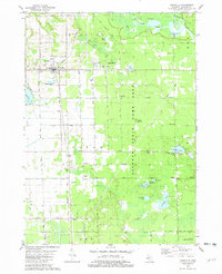
1981 Map of Fennville
USGS Topo · Published 1982About this map
The Chesapeake and Ohio railroad corridor anchors the western half of this Allegan County landscape, connecting the town of Fennville with the smaller settlements of Pearl and Bravo. The transition from the town's small industries and sandpits to the dense network of drainage and wildlife management is clear, particularly as the terrain yields to the Allegan State Game Area. Near the Kalamazoo River, the Ottawa Marsh and Big Dailey Bayou define a complex wetland environment where Big Goose Hole and various bayous illustrate the river's historical shifts.
Find a feature on this map
50 named features on this map. Tap any name to fly to it.
Don’t see what you’re looking for? This feature index may not catch every label — zoom into the map to look around manually.
Map Details
Editions of this 1981 Fennville Map
This is the sole edition of this map. No revisions or reprints were ever made.
Other maps of this area

1927 · Bangor
USGS Topo · 1:62,500

1928 · Fennville
USGS Topo · 1:62,500

1931 · Fennville
USGS Topo · 1:62,500

1931 · Bangor
USGS Topo · 1:62,500

1943 · Bangor
USGS Topo · 1:62,500

1946 · Gobles
USGS Topo · 1:62,500

1948 · Gobles
USGS Topo · 1:62,500

1949 · Gobles
USGS Topo · 1:62,500

1958 · Allegan
USGS Topo · 1:62,500

1958 · Racine
USGS Topo · 1:250,000