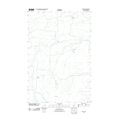
2011 Map of Fergus
USGS Topo · Published 2011About this map
Fergus serves as the central hub of this Central Montana landscape, situated where the East Fork Box Elder Creek meets the main branch of Box Elder Creek. The geography is defined by a series of north-flowing drainages including Brush Creek and Dry Armells Creek, which cut through the high plains. Significant topographical markers like Cone Butte in the south and Mitchell Canyon provide distinct landmarks for navigators and residents. Water management is evident through rural infrastructure such as Rindal Dam and Elderly Dam, supporting the ranching and agricultural operations connected by gravel routes like Romunstad Rd and Horse Ranch Rd. This map illustrates the sparse, organized settlement patterns of the Judith Basin area, where life revolves around the intersection of vital water sources and long-established road networks.
Find a feature on this map
14 named features on this map. Tap any name to fly to it.
Don’t see what you’re looking for? This feature index may not catch every label — zoom into the map to look around manually.
Map Details
Editions of this 2011 Fergus Map
This is the sole edition of this map. No revisions or reprints were ever made.
Other maps of this area

1941 · Judith Peak
USGS Topo · 1:62,500

1944 · Judith Peak
USGS Topo · 1:62,500

1954 · Lewistown
USGS Topo · 1:250,000

1959 · Lewistown
USGS Topo · 1:250,000

1978 · Lewistown
USGS Topo · 1:100,000

1985 · The Horse Ranch
USGS Topo · 1:24,000

1985 · Fergus
USGS Topo · 1:24,000

1985 · Roy
USGS Topo · 1:24,000

1985 · Armells
USGS Topo · 1:24,000
1985 · Roy NW
USGS Topo · 1:24,000