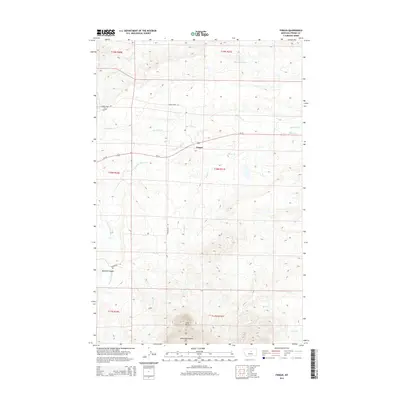
2014 Map of Fergus
USGS Topo · Published 2014About this map
The northern foothills of the Judith Mountains dominate this Central Montana landscape, anchored by the settlement of Fergus. This survey reveals a land defined by its drainages and ranching corridors, where Box Elder Cr and the E Fork Box Elder Cr carve through the high plains. In the southern reach of the quadrangle, Cone Butte stands as a prominent landmark above Mitchell Canyon, marking the transition into higher, more complex terrain. The map details a network of rural routes such as Horse Ranch Rd and Romunstad Rd that follow the natural contours of the land. Water management in this semi-arid region is represented by features like the Rindal Reservoir, illustrating the essential relationship between the ranching economy and the area's hydrology, including Dry Armells Cr and Brush Cr.
Find a feature on this map
22 named features on this map. Tap any name to fly to it.
Don’t see what you’re looking for? This feature index may not catch every label — zoom into the map to look around manually.
Map Details
Editions of this 2014 Fergus Map
This is the sole edition of this map. No revisions or reprints were ever made.
Other maps of this area

1941 · Judith Peak
USGS Topo · 1:62,500

1944 · Judith Peak
USGS Topo · 1:62,500

1954 · Lewistown
USGS Topo · 1:250,000

1959 · Lewistown
USGS Topo · 1:250,000

1978 · Lewistown
USGS Topo · 1:100,000

1985 · The Horse Ranch
USGS Topo · 1:24,000

1985 · Fergus
USGS Topo · 1:24,000

1985 · Roy
USGS Topo · 1:24,000

1985 · Armells
USGS Topo · 1:24,000
1985 · Roy NW
USGS Topo · 1:24,000