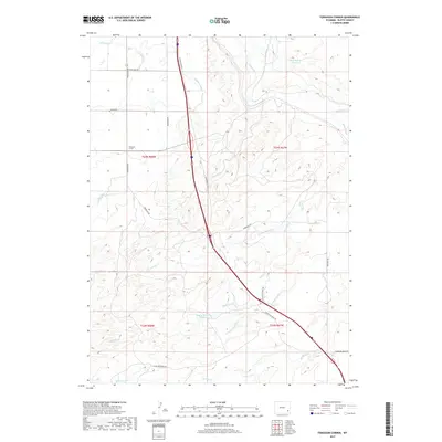
2017 Map of Ferguson Corner
USGS Topo · Published 2017About this map
Ferguson Corner serves as the focal point for this section of Platte County, where the high plains are carved by an intricate network of natural drainages and man-made irrigation systems. The landscape is defined by the central corridor of the S Wheatland Hwy, which cuts through a region dependent on water management for ranching and agriculture. Local engineering is evident in the presence of Canal Number 1, Highline Ditch, and the Bordeaux Canal, all designed to move water across the undulating terrain. Significant water storage is provided by the Chug Springs Reservoir in the northeast and Bagley Brothers Reservoir further south. Numerous watercourses such as Chugwater Cr and Antelope Cr flow through the territory, while roads like Bordeaux Rd and S Antelope Creek Rd connect remote ranching interests to the main thoroughfare.
Find a feature on this map
29 named features on this map. Tap any name to fly to it.
Don’t see what you’re looking for? This feature index may not catch every label — zoom into the map to look around manually.
Map Details
Editions of this 2017 Ferguson Corner Map
This is the sole edition of this map. No revisions or reprints were ever made.
Other maps of this area

1896 · Hartville
USGS Topo · 1:125,000

1901 · Hartville
USGS Topo · 1:125,000

1951 · Antelope Gap
USGS Topo · 1:24,000
1951 · Wheatland
USGS Topo · 1:24,000

1953 · Double L Ranch
USGS Topo · 1:24,000

1953 · Chugwater
USGS Topo · 1:24,000

1953 · Hightower
USGS Topo · 1:24,000

1953 · Natwick
USGS Topo · 1:24,000

1953 · Ferguson Corner
USGS Topo · 1:24,000

1953 · Bordeaux
USGS Topo · 1:24,000