
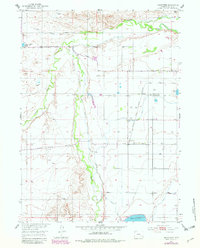
1953 Map of Hightower
USGS Topo · Published 1954About this map
Sybille Creek winds through this Platte County landscape, meeting the Laramie River in a region defined by early mid-century water management and ranching infrastructure. The map reveals an intricate network of irrigation, including the Colorado and Southern Canal, Mule Shoe Drain, and Iowa Lateral, all supporting the agricultural life around Wilson. Social and civic foundations of the era are visible at the Mountain View Community Hall and the already noted Wilkinson School (Aband). Local operations range from the State Game Farm to the small settlement at Hightower. The topography is marked by numerous windmills and cattle-related features, illustrating the transition from the high plains into the breaks of Palmer Canyon. This survey captures the rural character of Wyoming just as it was being integrated into the broader Missouri River Basin development program.
Find a feature on this map
27 named features on this map. Tap any name to fly to it.
Don’t see what you’re looking for? This feature index may not catch every label — zoom into the map to look around manually.
Map Details
Editions of this 1953 Hightower Map
2 editions found
Other maps of this area

1896 · Hartville
USGS Topo · 1:125,000

1901 · Hartville
USGS Topo · 1:125,000

1951 · Dwyer
USGS Topo · 1:24,000
1951 · Wheatland
USGS Topo · 1:24,000

1953 · Lewis Flat
USGS Topo · 1:24,000

1953 · Natwick
USGS Topo · 1:24,000

1953 · Squaw Rock
USGS Topo · 1:24,000

1953 · Ferguson Corner
USGS Topo · 1:24,000

1953 · Hightower SW
USGS Topo · 1:24,000

1953 · Johnson Mountain
USGS Topo · 1:24,000