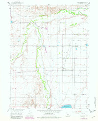
1953 Map of Hightower
USGS Topo · Published 1982About this map
Sybille Creek winds through this Platte County landscape, anchoring a rural territory defined by early water management and small-town infrastructure. The settlement of Hightower and the stop at Wilson sit along the Colorado and Southern (Burlington) railroad line, which served as the primary transit artery for this agricultural region. The map reveals an extensive network of irrigation, including the Mullen Ditch, Muleshoe Drain, and Iowa Lateral, reflecting the complex engineering required to support ranching and farming in the High Plains.
Find a feature on this map
29 named features on this map. Tap any name to fly to it.
Don’t see what you’re looking for? This feature index may not catch every label — zoom into the map to look around manually.
Map Details
Editions of this 1953 Hightower Map
2 editions found
Other maps of this area

1896 · Hartville
USGS Topo · 1:125,000

1901 · Hartville
USGS Topo · 1:125,000

1951 · Dwyer
USGS Topo · 1:24,000
1951 · Wheatland
USGS Topo · 1:24,000

1953 · Lewis Flat
USGS Topo · 1:24,000

1953 · Hightower
USGS Topo · 1:24,000

1953 · Natwick
USGS Topo · 1:24,000

1953 · Squaw Rock
USGS Topo · 1:24,000

1953 · Ferguson Corner
USGS Topo · 1:24,000

1953 · Hightower SW
USGS Topo · 1:24,000