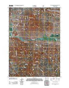
2011 Map of Ferguson Mountain
USGS Topo · Published 2011About this map
The Sprague River meanders across the center of this landscape, separating the high volcanic terrain of Ferguson Mountain to the north from the creek-carved slopes of Medicine Mountain to the south. Historically significant for the Klamath Basin, the Masekesket Cemetery and the Sycan Siding suggest the area's deep ties to tribal history and early rail development. The southern half of the map reveals a curious cluster of small water bodies with medicinal and industrial names, including Flu Pond, Pill Pond, Aspirin Pond, and Coke Pond. These features, along with Brown Creek and Mineral Creek, dominate a region crisscrossed by Forest Service routes like National Forest Rd 120. A passage at Beatty Gap provides a natural corridor near where Railroad Dr follows the riverbank, indicating the transit patterns of this rural Klamath County corridor.
Find a feature on this map
40 named features on this map. Tap any name to fly to it.
Don’t see what you’re looking for? This feature index may not catch every label — zoom into the map to look around manually.
Map Details
Editions of this 2011 Ferguson Mountain Map
This is the sole edition of this map. No revisions or reprints were ever made.
Other maps of this area

1889 · Klamath
USGS Topo · 1:250,000

1894 · Klamath
USGS Topo · 1:250,000

1955 · Klamath Falls
USGS Topo · 1:250,000

1958 · Klamath Falls
USGS Topo · 1:250,000

1960 · Riverbed Butte
USGS Topo · 1:62,500

1960 · Bly
USGS Topo · 1:62,500

1960 · Beatty
USGS Topo · 1:62,500

1960 · Fuego Mountain
USGS Topo · 1:62,500

1980 · Williamson River
USGS Topo · 1:100,000
1988 · Yainax Butte
USGS Topo · 1:24,000