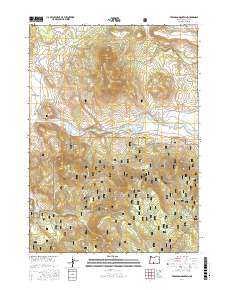
2017 Map of Ferguson Mountain
USGS Topo · Published 2017About this map
The Sprague River Valley serves as a central corridor in this portion of Klamath County, where the Sprague River winds through the landscape near Beatty Gap. To the north, the terrain is defined by the prominent peak of Ferguson Mtn, surrounded by a network of timber and access roads such as Ferguson Mtn Rd and Sycan Rd. The southern half of the sheet is dominated by the Fremont National Forest, featuring the heights of Medicine Mtn and the expanse of Bly Ridge.
Find a feature on this map
54 named features on this map. Tap any name to fly to it.
Don’t see what you’re looking for? This feature index may not catch every label — zoom into the map to look around manually.
Map Details
Editions of this 2017 Ferguson Mountain Map
This is the sole edition of this map. No revisions or reprints were ever made.
Other maps of this area

1889 · Klamath
USGS Topo · 1:250,000

1894 · Klamath
USGS Topo · 1:250,000

1955 · Klamath Falls
USGS Topo · 1:250,000

1958 · Klamath Falls
USGS Topo · 1:250,000

1960 · Riverbed Butte
USGS Topo · 1:62,500

1960 · Bly
USGS Topo · 1:62,500

1960 · Beatty
USGS Topo · 1:62,500

1960 · Fuego Mountain
USGS Topo · 1:62,500

1980 · Williamson River
USGS Topo · 1:100,000
1988 · Yainax Butte
USGS Topo · 1:24,000