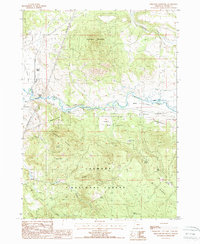
1988 Map of Ferguson Mountain
USGS Topo · Published 1988About this map
The Fremont National Forest dominates this landscape in southern Oregon, where the timber industry and high-desert geography intersect. A prominent Logging Railroad and a series of Steel Tower Trans Lines trace the valley of the Sprague River, illustrating the infrastructure required for resource extraction and utility distribution in the late 20th century. High points like Ferguson Mountain and Medicine Mountain overlook a complex network of water features, including several uniquely named ponds such as Flu Pond, Pill Pond, and Aspirin Pond. Small-scale evidence of early settlement and industry is found at Beatty Gap and Sycan Siding, while local history is marked by a lone Cem and family-named landmarks like Whiskey John Flat. The presence of the Elder Ditch, a Levee, and a Gaging Station reflects the managed nature of the water resources in the Sprague River Valley.
Find a feature on this map
34 named features on this map. Tap any name to fly to it.
Don’t see what you’re looking for? This feature index may not catch every label — zoom into the map to look around manually.
Map Details
Editions of this 1988 Ferguson Mountain Map
This is the sole edition of this map. No revisions or reprints were ever made.
Other maps of this area

1889 · Klamath
USGS Topo · 1:250,000

1894 · Klamath
USGS Topo · 1:250,000

1955 · Klamath Falls
USGS Topo · 1:250,000

1958 · Klamath Falls
USGS Topo · 1:250,000

1960 · Riverbed Butte
USGS Topo · 1:62,500

1960 · Bly
USGS Topo · 1:62,500

1960 · Beatty
USGS Topo · 1:62,500

1960 · Fuego Mountain
USGS Topo · 1:62,500

1980 · Williamson River
USGS Topo · 1:100,000
1988 · Yainax Butte
USGS Topo · 1:24,000