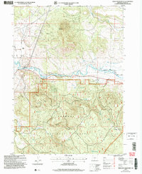
2004 Map of Ferguson Mountain
USGS Topo · Published 2004About this map
The Sprague River meanders through the northern reaches of this landscape, carving a wide valley floor before narrowing at Beatty Gap. This area, heavily shaped by the timber and water needs of the Klamath Basin, shows a complex network of hydrological management features like the Elder Ditch, various flumes, and a Levee system designed to control seasonal flows. Near the western edge, the Sycan Siding represents the vital rail infrastructure that once supported local industry, situated just south of the Sprague Valley Road.
Find a feature on this map
31 named features on this map. Tap any name to fly to it.
Don’t see what you’re looking for? This feature index may not catch every label — zoom into the map to look around manually.
Map Details
Editions of this 2004 Ferguson Mountain Map
This is the sole edition of this map. No revisions or reprints were ever made.
Other maps of this area

1889 · Klamath
USGS Topo · 1:250,000

1894 · Klamath
USGS Topo · 1:250,000

1955 · Klamath Falls
USGS Topo · 1:250,000

1958 · Klamath Falls
USGS Topo · 1:250,000

1960 · Riverbed Butte
USGS Topo · 1:62,500

1960 · Bly
USGS Topo · 1:62,500

1960 · Beatty
USGS Topo · 1:62,500

1960 · Fuego Mountain
USGS Topo · 1:62,500

1980 · Williamson River
USGS Topo · 1:100,000
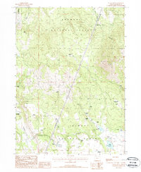
1988 · Yainax Butte
USGS Topo · 1:24,000