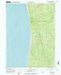
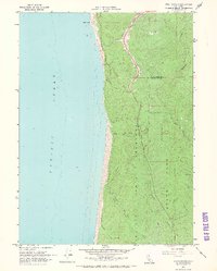
1966 Map of Fern Canyon
USGS Topo · Published 1968About this map
Prairie Creek Redwoods State Park dominates this coastal landscape, where the redwood forest meets the steep shoreline of the Pacific Ocean. This 1966 field-checked survey highlights the complex drainage system of the North Coast, featuring the eponymous Fern Canyon and the towering Gold Bluffs. The map documents a primitive network of access, notably the series of numbered paths including Zigzag Trail 1, Zigzag Tr 2, and Zigzag Trail 3, which descend toward the beach from the interior ridges. Numerous coastal streams like Ossagon Creek and Butler Creek cut through the bluffs, while the eastern portion of the sheet follows the upper reaches of Ah Pah Creek across the Del Norte Co Humboldt Co line. This survey was produced as a collaboration between the U.S. Geological Survey and the California Department of Water Resources, capturing the region's hydrography before modern infrastructure expansions.
Find a feature on this map
35 named features on this map. Tap any name to fly to it.
Don’t see what you’re looking for? This feature index may not catch every label — zoom into the map to look around manually.
Map Details
Editions of this 1966 Fern Canyon Map
2 editions found
Other maps of this area

1922 · Preston Peak
USGS Topo · 1:125,000

1925 · Hoopa
USGS Topo · 1:125,000

1929 · Crescent City
USGS Topo · 1:125,000

1945 · Ship Mountain
USGS Topo · 1:62,500

1945 · Orick
USGS Topo · 1:62,500

1945 · Requa
USGS Topo · 1:62,500

1945 · Tectah Creek
USGS Topo · 1:62,500

1948 · Weed
USGS Topo · 1:250,000

1949 · Eureka
USGS Topo · 1:250,000

1950 · Weed
USGS Topo · 1:250,000