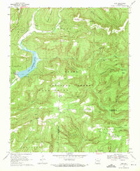
1969 Map of Fern
USGS Topo · Published 1971About this map
Lake Shepherd Springs dominates the western landscape of this 1969 survey, where the waters of Frog Bayou are gathered within the high ridges of the Ozark National Forest. The map documents a rugged interior of the Boston Mountains, characterized by steep hollows like Gabbard Hollow and Rattlesnake Hollow that drain into the Mulberry River and its various tributaries. Small settlements and rural hubs such as Fern and Locke serve as the primary points of human geography, connected by winding mountain roads.
Find a feature on this map
56 named features on this map. Tap any name to fly to it.
Don’t see what you’re looking for? This feature index may not catch every label — zoom into the map to look around manually.
Map Details
Editions of this 1969 Fern Map
3 editions found
Other maps of this area

1879 · Cravens
USGS Topo · 1:62,500

1887 · Watalula
USGS Topo · 1:62,500

1898 · Winslow #4
USGS Topo · 1:62,500

1898 · Winslow
USGS Topo · 1:125,000

1901 · Winslow
USGS Topo · 1:125,000

1939 · Watalula
USGS Topo · 1:62,500

1943 · St. Paul
USGS Topo · 1:62,500

1946 · St. Paul
USGS Topo · 1:62,500

1946 · Fort Smith
USGS Topo · 1:250,000

1956 · Russellville
USGS Topo · 1:250,000