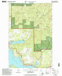
1996 Map of Fernan Lake
USGS Topo · Published 1999About this map
Fernan Lake sits at the heart of this landscape, its waters reaching into the western edge of the Coeur d'Alene National Forest. The map documents a period of suburban transition where the residential streets of Dalton Gardens and Fernan Lake Village meet the steep, forested drainages of Nettleton Gulch and French Gulch. This interface between developed Idaho lakeside communities and the timbered heights of West Canfield Butte and East Canfield Butte highlights the region's topography, where the high ridges of Folsom Ridge and Kelly Mountain overlook the expansive Coeur d'Alene Lake. Further south, the map traces the shoreline of Blue Creek Bay and Wolf Lodge Bay, documenting infrastructure like the Veterans Memorial Bridge and the historic route of the Yellowstone Trail as they navigate the shoreline terrain.
Find a feature on this map
48 named features on this map. Tap any name to fly to it.
Don’t see what you’re looking for? This feature index may not catch every label — zoom into the map to look around manually.
Map Details
Editions of this 1996 Fernan Lake Map
This is the sole edition of this map. No revisions or reprints were ever made.
Other maps of this area

1903 · Rathdrum
USGS Topo · 1:125,000

1955 · Spokane
USGS Topo · 1:250,000

1957 · Coeur D'Alene
USGS Topo · 1:62,500

1957 · Lane
USGS Topo · 1:62,500

1958 · Spokane
USGS Topo · 1:250,000

1961 · Hayden
USGS Topo · 1:24,000

1961 · Spirit Lake
USGS Topo · 1:62,500

1961 · Athol
USGS Topo · 1:62,500

1961 · Hayden Lake
USGS Topo · 1:24,000

1975 · Coeur D'Alene SE
USGS Topo · 1:24,000