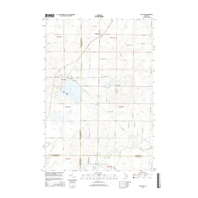
2014 Map of Fife Lake
USGS Topo · Published 2014About this map
The waters of Fife Lake dominate the geography where Grand Traverse, Kalkaska, and Wexford counties converge. This 2014 survey documents the village of Fife Lake along the northwestern shore, featuring both Florence Island and Helen Island within the basin. To the north, the small settlement of Houseman sits along the roadway, while the Manistee River cuts across the southeastern corner of the quadrangle, joined by tributaries like Hopkins Cr and Spring Cr. The land use is defined by a mix of forestry and aviation, noted by Tannehill Airfield to the north. Local history is anchored by several burial grounds, including Saint Aloysius Cem and Fife Lake Cem near the village, and the more secluded Clark Cem situated to the southeast, providing valuable points of reference for genealogists tracking family plots in this corner of Michigan.
Find a feature on this map
89 named features on this map. Tap any name to fly to it.
Don’t see what you’re looking for? This feature index may not catch every label — zoom into the map to look around manually.
Map Details
Editions of this 2014 Fife Lake Map
This is the sole edition of this map. No revisions or reprints were ever made.
Other maps of this area

1954 · Traverse City
USGS Topo · 1:250,000

1956 · Kalkaska
USGS Topo · 1:62,500

1956 · Fife Lake
USGS Topo · 1:62,500

1956 · Cadillac North
USGS Topo · 1:62,500

1956 · Lake City
USGS Topo · 1:62,500

1958 · Traverse City
USGS Topo · 1:250,000

1983 · Cadillac
USGS Topo · 1:100,000

1983 · Manton
USGS Topo · 1:25,000

1983 · Traverse City
USGS Topo · 1:100,000
1983 · Morey
USGS Topo · 1:25,000
Featured Places
- Fife Lake Township, MI
- Union Township, MI
- Fife Lake, Fife Lake Township
- Boardman Township, MI
- Bloomfield Township, MI