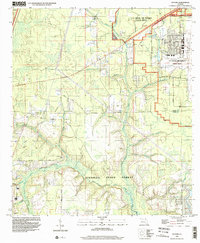
1994 Map of Fiftone
USGS Topo · Published 2002About this map
Jennings State Forest and the expansive grounds of the U S Naval Air Station (Cecil Field) dominate this North Florida landscape along the border of Duval and Clay counties. The 1994 imagery reveals a transition from the structured military installation in the northeast—complete with its Radio Tower, Substation, and athletic fields—to the dense creek-fed woodlands of the state forest. The terrain is defined by the winding Black Creek North Fork and its many tributaries, including Yellow Water Branch and Taylor Creek. Small rural settlements and family landmarks are scattered throughout the pine woods, including the namesake community of Fiftone. The map provides a look at local history through its numerous small burial grounds and rural congregations, such as Padsett Cem, Manning Cem, and Long Branch Ch, which are often linked by unpaved tracks like Turpentine Road.
Find a feature on this map
40 named features on this map. Tap any name to fly to it.
Don’t see what you’re looking for? This feature index may not catch every label — zoom into the map to look around manually.
Map Details
Editions of this 1994 Fiftone Map
This is the sole edition of this map. No revisions or reprints were ever made.
Other maps of this area

1917 · Cambon
USGS Topo · 1:62,500

1917 · Macclenny
USGS Topo · 1:62,500

1918 · Middleburg
USGS Topo · 1:62,500

1918 · Lawtey
USGS Topo · 1:62,500

1918 · Cambon
USGS Topo · 1:62,500

1918 · Macclenny
USGS Topo · 1:62,500

1941 · Middleburg
USGS Topo · 1:62,500

1948 · Jacksonville
USGS Topo · 1:250,000

1949 · Middleburg SW
USGS Topo · 1:24,000

1949 · Fiftone
USGS Topo · 1:24,000