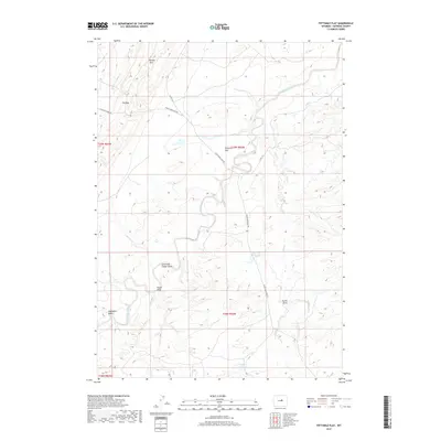
2017 Map of Fiftymile Flat
USGS Topo · Published 2017About this map
Fiftymile Flat lies in a remote stretch of Natrona County, where the high plains are carved by a complex network of seasonal drainages and named coulees. The landscape is defined by the winding course of the S Fork Powder River, which meanders through the central terrain alongside numerous draws including Stone and Timber Draw and Foster Draw. Elevated landmarks such as Broken Horn and The Gap break the horizon, providing orientation in a region largely dedicated to open range and water management. Sparse infrastructure is represented by rural routes like Thirtythree Mile Rd and scattered stock water sources such as Blue Hill Reservoir and Three T Reservoir. These features illustrate the essential relationship between geography and cattle ranching in the Wyoming interior during the early 21st century.
Find a feature on this map
21 named features on this map. Tap any name to fly to it.
Don’t see what you’re looking for? This feature index may not catch every label — zoom into the map to look around manually.
Map Details
Editions of this 2017 Fiftymile Flat Map
This is the sole edition of this map. No revisions or reprints were ever made.
Other maps of this area

1955 · Arminto
USGS Topo · 1:250,000

1958 · Arminto
USGS Topo · 1:250,000

1962 · Arminto
USGS Topo · 1:250,000

1968 · Willow Creek School
USGS Topo · 1:24,000

1968 · Merino
USGS Topo · 1:24,000

1968 · Camel Hump Reservoir
USGS Topo · 1:24,000

1968 · Reynolds Reservoir
USGS Topo · 1:24,000

1968 · Big Sulfur Draw
USGS Topo · 1:24,000

1968 · Fiftymile Flat
USGS Topo · 1:24,000
1968 · Anderson Draw
USGS Topo · 1:24,000