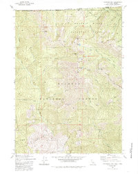
1980 Map of Figurehead Mtn
USGS Topo · Published 1985About this map
Rogue River National Forest, Siskiyou National Forest, and Klamath National Forest converge in this high-elevation wilderness along the Oregon-California border. The terrain is characterized by steep peaks such as Figurehead Mtn and Mount Emily, with high-mountain lakes including Azalea Lake, Snake Lake, and Lonesome Lake providing remote landmarks. The drainage network is defined by the Middle Fork Applegate River and its numerous tributaries like Butte Fork Applegate River and Sweaty Gulch. While largely a roadless wilderness, the presence of Baileys Cabin (Site) and the Mohawk Mine Gulch suggests a history of early habitation and resource extraction. Navigational infrastructure is limited to a network of Trails and Pack Trails, emphasizing the area's isolation during the late 20th century survey period.
Find a feature on this map
55 named features on this map. Tap any name to fly to it.
Don’t see what you’re looking for? This feature index may not catch every label — zoom into the map to look around manually.
Map Details
Editions of this 1980 Figurehead Mtn Map
2 editions found
Other maps of this area

1908 · Grants Pass
USGS Topo · 1:125,000

1914 · Seiad
USGS Topo · 1:125,000

1922 · Seiad
USGS Topo · 1:125,000

1948 · Weed
USGS Topo · 1:250,000

1950 · Weed
USGS Topo · 1:250,000

1954 · Oregon Caves
USGS Topo · 1:62,500

1954 · Ruch
USGS Topo · 1:62,500

1955 · Seiad Valley
USGS Topo · 1:62,500

1955 · Medford
USGS Topo · 1:250,000

1956 · Happy Camp
USGS Topo · 1:62,500