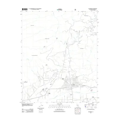
2012 Map of Fillmore
USGS Topo · Published 2012About this map
Fillmore sits at the base of the Los Padres foothills where the Santa Clara River meets Sespe Cr. This 2012 survey illustrates the valley’s agricultural and municipal character, highlighting specialized sites like the Fillmore School Farm and the Fillmore State Fish Hatchery to the southeast. The street grid of North Fillmore and the central city is dense with residential roads such as Blaine Ave and 7th St, while smaller residential clusters like Oak Village, Sespe Village, and Keith appear along Keith Rd. To the north, the terrain rises sharply toward San Cayetano Mountain and Oat Mountain. The landscape is carved by numerous canyons and washes, including Snow Canyon and Pole Canyon, while remote locations like Van Tries Ranch mark the transition into the more wilderness-oriented reaches of Bear Heaven.
Find a feature on this map
81 named features on this map. Tap any name to fly to it.
Don’t see what you’re looking for? This feature index may not catch every label — zoom into the map to look around manually.
Map Details
Editions of this 2012 Fillmore Map
This is the sole edition of this map. No revisions or reprints were ever made.
Other maps of this area

1900 · Piru
USGS Topo · 1:62,500

1903 · Santa Paula
USGS Topo · 1:62,500

1903 · Mt. Pinos
USGS Topo · 1:125,000

1903 · Tejon
USGS Topo · 1:125,000

1903 · Camulos
USGS Topo · 1:125,000

1921 · Piru
USGS Topo · 1:62,500

1941 · Piru
USGS Topo · 1:62,500

1942 · Santa Paula
USGS Topo · 1:62,500

1943 · Topatopa Mountains
USGS Topo · 1:24,000
1943 · Devils Heart Peak
USGS Topo · 1:24,000