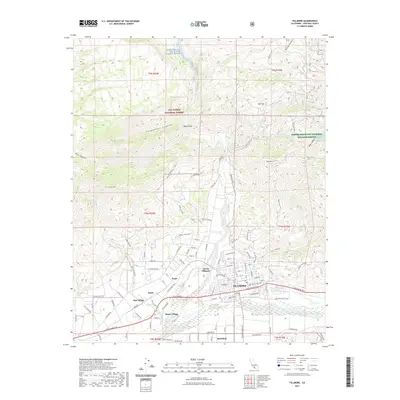
2021 Map of Fillmore
USGS Topo · Published 2021About this map
Fillmore and its neighboring agricultural communities are situated at the confluence of Sespe Creek and the Santa Clara River in Ventura County. This 2021 survey illustrates a valley landscape defined by citrus groves and established settlements like Bardsdale, Sespe Village, and North Fillmore. The transition from the flat, cultivated valley floor to the steep elevations of the Los Padres National Forest is immediate, with San Cayetano Mountain and Oat Mountain flanking the northern canyons. To the northeast, the Hopper Mountain National Wildlife Refuge provides a protected sanctuary in the high country. Significant waterways such as the Sespe Creek Wild and Scenic River course through deep incisions like Coldwater Canyon and Pine Canyon, highlighting the complex drainage patterns that feed the river valley below.
Find a feature on this map
119 named features on this map. Tap any name to fly to it.
Don’t see what you’re looking for? This feature index may not catch every label — zoom into the map to look around manually.
Map Details
Editions of this 2021 Fillmore Map
This is the sole edition of this map. No revisions or reprints were ever made.
Other maps of this area

1900 · Piru
USGS Topo · 1:62,500

1903 · Santa Paula
USGS Topo · 1:62,500

1903 · Mt. Pinos
USGS Topo · 1:125,000

1903 · Tejon
USGS Topo · 1:125,000

1903 · Camulos
USGS Topo · 1:125,000

1921 · Piru
USGS Topo · 1:62,500

1941 · Piru
USGS Topo · 1:62,500

1942 · Santa Paula
USGS Topo · 1:62,500

1943 · Topatopa Mountains
USGS Topo · 1:24,000
1943 · Devils Heart Peak
USGS Topo · 1:24,000