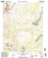
2001 Map of Finger Mesa
USGS Topo · Published 2005About this map
The Continental Divide winds through this high-altitude landscape of Hinsdale County, separating the headwaters of the Rio Grande National Forest and the Gunnison National Forest. Centered on the prominent Finger Mesa, the area is defined by massive water management features including the Continental Reservoir to the northeast and the Rio Grande Reservoir at the southern edge. Small-scale mountain habitations such as Lost Trail Ranch and Ski Hi Ranch are documented near the southern valley floor, connected by the Lost Trail and the eponymous Footbridge. Evidence of resource extraction remains visible through identified Prospects and a Mine located along the upper reaches of the divide, while the southern portion of the quadrangle transitions into the protected Weminuche Wilderness.
Find a feature on this map
35 named features on this map. Tap any name to fly to it.
Don’t see what you’re looking for? This feature index may not catch every label — zoom into the map to look around manually.
Map Details
Editions of this 2001 Finger Mesa Map
This is the sole edition of this map. No revisions or reprints were ever made.
Other maps of this area

1905 · San Cristobal
USGS Topo · 1:125,000

1907 · San Cristobal
USGS Topo · 1:125,000

1945 · Durango
USGS Topo · 1:250,000

1953 · Durango
USGS Topo · 1:250,000

1954 · Durango
USGS Topo · 1:250,000

1959 · Bristol Head
USGS Topo · 1:62,500

1961 · Durango
USGS Topo · 1:250,000

1963 · Durango
USGS Topo · 1:250,000
1964 · Rio Grande Pyramid
USGS Topo · 1:24,000
1964 · Finger Mesa
USGS Topo · 1:24,000