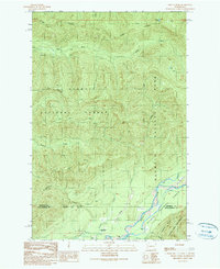
1990 Map of Finley Creek
USGS Topo · Published 1990About this map
Sams Ridge and Matheny Ridge dominate this corner of the Olympic Peninsula, where the landscape transitions across high-altitude boundaries. The southern portion of the map is defined by the Quinault River, which marks the divide between Jefferson and Grays Harbor counties. This 1990 edition captures the region as it was managed by various federal agencies, showing the intersecting lines of the Olympic National Park and the Olympic National Forest. Within the forest lands, human activity is evident through small-scale extractive sites such as Quarries and a Borrow Pit. Along the river valley, the Quinault River Ranger Sta serves as a lone hub for wilderness management near the entrance to the Colonel Bob Wilderness. Waterways like Finley Creek and Matheny Creek carve through the steep terrain, feeding into the larger river system from high-mountain sources like Round Lake and Lilly Lake.
Find a feature on this map
20 named features on this map. Tap any name to fly to it.
Don’t see what you’re looking for? This feature index may not catch every label — zoom into the map to look around manually.
Map Details
Editions of this 1990 Finley Creek Map
This is the sole edition of this map. No revisions or reprints were ever made.
Other maps of this area

1921 · Quinault Lake
USGS Topo · 1:62,500

1921 · Satsop
USGS Topo · 1:62,500

1947 · Mt Christie
USGS Topo · 1:62,500

1950 · Mt Christie
USGS Topo · 1:62,500

1955 · Grisdale
USGS Topo · 1:62,500

1955 · Quinault Lake
USGS Topo · 1:62,500

1956 · Kloochman Rock
USGS Topo · 1:62,500

1958 · Seattle
USGS Topo · 1:250,000

1962 · Seattle
USGS Topo · 1:250,000
1988 · Shelton
USGS Topo · 1:100,000