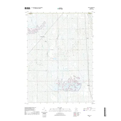
2018 Map of Finley
USGS Topo · Published 2018About this map
Meadow Valley and the small settlement of Finley sit within a highly engineered wetland landscape in Juneau County, characterized by an extensive network of water control features. This 2018 survey documents a complex system of ditches and laterals, including the Spencer-Robinson Ditch and the Albrecht Lateral, which manage the flow of the Little Yellow River. Large impoundments like Greenhead Flowage, Goose Pool, and Number Thirteen Pool dominate the terrain, reflecting the area's importance for water management and habitat conservation. Genealogists may find interest in the Meadow Valley Cem, while the grid of rural roads like Finley Rd and Johnson Rd provides a clear view of the area's modern spatial organization near the Wood County line. The map highlights a transition from traditional settlements like Sprague to a landscape defined by industrial-scale drainage and reservoir pools.
Find a feature on this map
43 named features on this map. Tap any name to fly to it.
Don’t see what you’re looking for? This feature index may not catch every label — zoom into the map to look around manually.
Map Details
Editions of this 2018 Finley Map
This is the sole edition of this map. No revisions or reprints were ever made.
Other maps of this area

1953 · Eau Claire
USGS Topo · 1:250,000

1957 · Pittsville
USGS Topo · 1:48,000

1957 · City Point
USGS Topo · 1:48,000

1958 · Eau Claire
USGS Topo · 1:250,000

1958 · Necedah
USGS Topo · 1:48,000

1958 · Wyeville
USGS Topo · 1:48,000

1964 · Eau Claire
USGS Topo · 1:250,000

1967 · Pittsville
USGS Topo · 1:62,500
1969 · New Miner
USGS Topo · 1:24,000
1969 · Cutler
USGS Topo · 1:24,000