
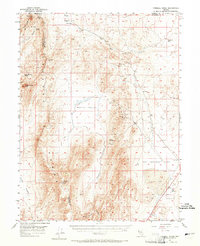
1957 Map of Fireball Ridge
USGS Topo · Published 1959About this map
Fireball Ridge and the Truckee Range dominate this Nevada landscape, where the convergence of Washoe, Pershing, and Churchill counties meets a high-desert environment defined by mining and scarce water. Prospectors and geologists in the late 1950s documented numerous industrial traces, including the Jay Bird Mine, several Shafts, and a network of Tunnel and Prospects operations concentrated along the ridges. This terrain is characterized by dramatic elevation changes from peaks like Black Warrior Peak and Nache Peak down to the expansive, arid basins of Alkali Flat and Hot Springs Flat. Resource extraction and livestock survival relied on critical water points such as Sage Hen Creek, Black Warrior Spring, and Telephone Well. A sparse network of Jeep Trails provides the only passage through this unforgiving territory, connecting isolated canyons like Coyote Canyon and Miry Place Canyon.
Find a feature on this map
31 named features on this map. Tap any name to fly to it.
Don’t see what you’re looking for? This feature index may not catch every label — zoom into the map to look around manually.
Map Details
Editions of this 1957 Fireball Ridge Map
2 editions found
Other maps of this area

1886 · Granite Range
USGS Topo · 1:250,000

1890 · Wadsworth
USGS Topo · 1:125,000

1892 · Wadsworth
USGS Topo · 1:125,000

1894 · Granite Range
USGS Topo · 1:250,000

1894 · Wadsworth
USGS Topo · 1:125,000

1908 · Carson Sink
USGS Topo · 1:250,000

1910 · Carson Sink
USGS Topo · 1:250,000

1931 · Lovelock
USGS Topo · 1:250,000

1935 · Lovelock
USGS Topo · 1:250,000

1951 · Soda Lake
USGS Topo · 1:62,500