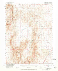
1957 Map of Fireball Ridge
USGS Topo · Published 1965About this map
Fireball Ridge and the Nightingale Mts dominate this mid-century desert landscape along the border of Washoe and Churchill counties. The map captures a high-desert environment defined by extremes, from the alkaline desolation of Alkali Flat and Hot Springs Flat to the high elevations of Black Warrior Peak and Juniper Peak. Human activity in the late 1950s was largely concentrated on extraction and basic survival, marked by several Prospects, a Quarry, and the Ivy Bird Mine in the northern reaches. Water sources were critical landmarks for travelers and miners, evidenced by named features like Coyote Spring, Black Warrior Spring, and the functional Telephone Well. The lack of established settlements highlights the transitory nature of work in this corner of the Great Basin, where seasonal canyons like Tolbert Canyon and Miry Place Canyon provided the primary corridors through the mountain terrain.
Find a feature on this map
27 named features on this map. Tap any name to fly to it.
Don’t see what you’re looking for? This feature index may not catch every label — zoom into the map to look around manually.
Map Details
Editions of this 1957 Fireball Ridge Map
2 editions found

Other maps of this area

1886 · Granite Range
USGS Topo · 1:250,000

1890 · Wadsworth
USGS Topo · 1:125,000

1892 · Wadsworth
USGS Topo · 1:125,000

1894 · Granite Range
USGS Topo · 1:250,000

1894 · Wadsworth
USGS Topo · 1:125,000

1908 · Carson Sink
USGS Topo · 1:250,000

1910 · Carson Sink
USGS Topo · 1:250,000

1931 · Lovelock
USGS Topo · 1:250,000

1935 · Lovelock
USGS Topo · 1:250,000

1951 · Soda Lake
USGS Topo · 1:62,500