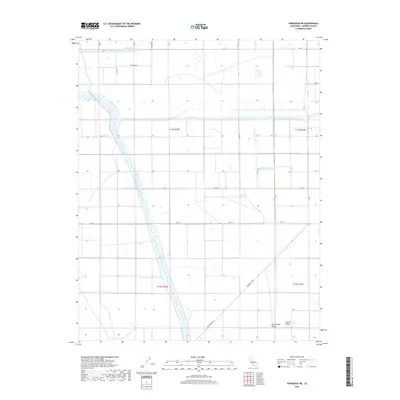
2018 Map of Firebaugh NE
USGS Topo · Published 2018About this map
The agricultural grid of the San Joaquin Valley is defined by a sophisticated network of waterways designed to manage the arid landscape of Madera County. Dominating the western half of the terrain, the Chowchilla Canal runs in a prominent north-south diagonal, cutting across the rigid section lines of the Public Land Survey System. This major infrastructure is supported by the Califa Canal and the meandering course of the Fresno River, which flows westward toward the central valley floor. In the northern reaches, Berenda Slough provides further evidence of the region's managed hydrology. The map illustrates a landscape transitioned entirely to large-scale cultivation, where the geometric precision of roads like Firebaugh Blvd and Ave 17 coordinate with the movement of water to sustain the fertile Central Valley.
Find a feature on this map
18 named features on this map. Tap any name to fly to it.
Don’t see what you’re looking for? This feature index may not catch every label — zoom into the map to look around manually.
Map Details
Editions of this 2018 Firebaugh NE Map
This is the sole edition of this map. No revisions or reprints were ever made.
Other maps of this area

1916 · Berenda
USGS Topo · 1:31,680

1918 · Bliss Ranch
USGS Topo · 1:31,680

1918 · Chowchilla
USGS Topo · 1:31,680

1918 · Berenda
USGS Topo · 1:31,680

1920 · Bonita Ranch
USGS Topo · 1:31,680

1921 · Mendota
USGS Topo · 1:31,680

1921 · Bonita Ranch
USGS Topo · 1:31,680

1922 · Pozo Farm
USGS Topo · 1:31,680

1922 · Kentucky Well
USGS Topo · 1:31,680

1923 · Firebaugh
USGS Topo · 1:31,680