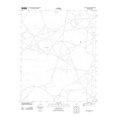
2011 Map of First Flat Mesa
USGS Topo · Published 2011About this map
First Flat Mesa and Second Flat Mesa dominate this high-desert landscape in Navajo County, representing a section of the Navajo Nation near the Fort Defiance Agency. This 2011 survey reveals an arid environment defined by isolated water sources such as Cottonwood Spring, Rainbow Spring, and Coyote Spring, which traditionally served as vital points for livestock and local habitation. The topography is marked by significant elevations like Stephen Butte in the north. A complex network of tribal roads, including Whitecone Rd and various routes like Indian Rte-9065, cross the terrain, illustrating the modern infrastructure used to navigate these traditional lands. The map captures the intersection of natural geological formations and the human footprint of the early 21st century.
Find a feature on this map
12 named features on this map. Tap any name to fly to it.
Don’t see what you’re looking for? This feature index may not catch every label — zoom into the map to look around manually.
Map Details
Editions of this 2011 First Flat Mesa Map
This is the sole edition of this map. No revisions or reprints were ever made.
Other maps of this area

1883 · Tusayan
USGS Topo · 1:250,000

1886 · Tusayan
USGS Topo · 1:250,000

1947 · Flagstaff
USGS Topo · 1:250,000

1954 · Flagstaff
USGS Topo · 1:250,000

1958 · Flagstaff
USGS Topo · 1:250,000

1960 · Flagstaff
USGS Topo · 1:250,000

1962 · Flagstaff
USGS Topo · 1:250,000

1966 · White Cone
USGS Topo · 1:62,500

1966 · Egloffstein Butte
USGS Topo · 1:62,500
1967 · Dilkon
USGS Topo · 1:24,000