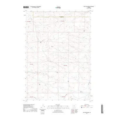
2017 Map of First Water Draw
USGS Topo · Published 2017About this map
First Water Draw sits at the heart of this high-altitude landscape where the boundary of Johnson Co and Natrona Co meets. The terrain is characterized by dramatic escarpments and basins, notably the Beaton Basin and the striking prominence of the Red Wall in the south. This 2017 survey reveals a network of seasonal watercourses and remote springs that have long dictated movement through this country. Water sources like Clapp Spring and the drainage of Lost Canyon are critical landmarks in an area dominated by cattle ranching and resource management. The map details a sparsely populated interior connected by remote routes such as Buffalo Creek Rd and Slope Rd, which navigate the steep elevations of Taylor Slope and the Black Rim. This cartographic record is essential for understanding the modern footprint of land use and topography in this corner of Wyoming.
Find a feature on this map
24 named features on this map. Tap any name to fly to it.
Don’t see what you’re looking for? This feature index may not catch every label — zoom into the map to look around manually.
Map Details
Editions of this 2017 First Water Draw Map
This is the sole edition of this map. No revisions or reprints were ever made.
Other maps of this area

1952 · Deadman Butte
USGS Topo · 1:24,000

1952 · Grave Spring
USGS Topo · 1:24,000

1955 · Arminto
USGS Topo · 1:250,000

1958 · Arminto
USGS Topo · 1:250,000

1961 · Barnum
USGS Topo · 1:62,500

1962 · Arminto
USGS Topo · 1:250,000

1967 · Gordon Creek
USGS Topo · 1:24,000
1967 · Cherry Creek Hill
USGS Topo · 1:24,000

1968 · First Water Draw
USGS Topo · 1:24,000

1968 · Roughlock Hill
USGS Topo · 1:24,000