
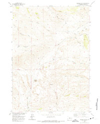
1952 Map of Deadman Butte
USGS Topo · Published 1953About this map
Deadman Butte anchors this Natrona County landscape, which was surveyed during the early 1950s as part of the Department of the Interior's Missouri River Basin development program. The terrain is defined by a complex drainage network where the North Fork Cottonwood Creek and South Fork Cottonwood Creek converge. Named water features like Sanchez Creek and Sanchez Spring suggest early ranching or homesteading influences in this arid region, while the presence of Buffalo Creek and Baker Creek further illustrates the vital importance of seasonal water sources for western land use.
Find a feature on this map
10 named features on this map. Tap any name to fly to it.
Don’t see what you’re looking for? This feature index may not catch every label — zoom into the map to look around manually.
Map Details
Editions of this 1952 Deadman Butte Map
2 editions found
Other maps of this area

1952 · Grave Spring
USGS Topo · 1:24,000

1952 · Arminto
USGS Topo · 1:24,000

1952 · Waltman NW
USGS Topo · 1:24,000

1952 · Badwater NE
USGS Topo · 1:24,000

1952 · Badwater SE
USGS Topo · 1:24,000

1955 · Arminto
USGS Topo · 1:250,000

1958 · Arminto
USGS Topo · 1:250,000

1962 · Arminto
USGS Topo · 1:250,000

1968 · First Water Draw
USGS Topo · 1:24,000
1968 · Notches Dome
USGS Topo · 1:24,000