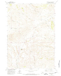
1952 Map of Deadman Butte
USGS Topo · Published 1975About this map
The Bighorn Mountains cast a long shadow over this remote section of Natrona County, where the southern reaches of the range meet the high plains. The landscape is defined by the striking Red Wall escarpment and the prominent Deadman Butte, which serves as a central landmark for the surrounding drainage systems. These drainages, including the North Fork Cottonwood Creek and the South Fork Cottonwood Creek, represent the critical water sources that dictated early movement and land use in this arid region.
Find a feature on this map
15 named features on this map. Tap any name to fly to it.
Don’t see what you’re looking for? This feature index may not catch every label — zoom into the map to look around manually.
Map Details
Editions of this 1952 Deadman Butte Map
2 editions found
Other maps of this area

1952 · Deadman Butte
USGS Topo · 1:24,000

1952 · Grave Spring
USGS Topo · 1:24,000

1952 · Arminto
USGS Topo · 1:24,000

1952 · Waltman NW
USGS Topo · 1:24,000

1952 · Badwater NE
USGS Topo · 1:24,000

1952 · Badwater SE
USGS Topo · 1:24,000

1955 · Arminto
USGS Topo · 1:250,000

1958 · Arminto
USGS Topo · 1:250,000

1962 · Arminto
USGS Topo · 1:250,000

1968 · First Water Draw
USGS Topo · 1:24,000