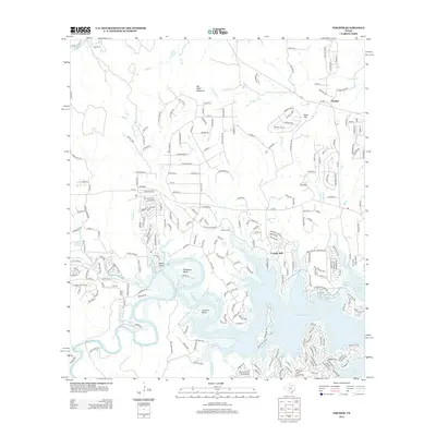
2013 Map of Fischer
USGS Topo · Published 2013About this map
The waters of Canyon Lake dominate this 2013 survey of the Texas Hill Country, illustrating the transformation of the upper Guadalupe River valley. The map details the developed shoreline near Cranes Mill, where the terrain transitions from the inundated riverbed to the rugged limestone uplands of Big Head Mountain and Kuhn Hill. Local history is preserved in the location of the Bremer Cem and the small settlement of Fischer to the northeast. Several significant hydrologic features are noted, including Rebecca Springs, Bishop Spring, and Cranes Mill Springs, which historically fed the local creeks before the reservoir's creation. The winding course of the original river channel is still evidenced by the dramatic topography of Demijohn Bend and Cordova Bend, now part of the reservoir's complex shoreline. Residential growth is visible in the dense network of roads like Mystic Pkwy and Vista View Pl, reflecting the area's modern character as a lakeside community.
Find a feature on this map
247 named features on this map. Tap any name to fly to it.
Don’t see what you’re looking for? This feature index may not catch every label — zoom into the map to look around manually.
Map Details
Editions of this 2013 Fischer Map
This is the sole edition of this map. No revisions or reprints were ever made.
Other maps of this area

1887 · Blanco
USGS Topo · 1:125,000

1894 · Blanco
USGS Topo · 1:125,000

1920 · Smithsons Valley
USGS Topo · 1:62,500

1925 · Hunter No 3
USGS Topo · 1:48,000

1925 · Smithson Valley No. 1
USGS Topo · 1:48,000

1927 · Smithson Valley
USGS Topo · 1:62,500

1929 · Hunter
USGS Topo · 1:62,500

1929 · Smithson Valley
USGS Topo · 1:62,500

1940 · Smithson Valley
USGS Topo · 1:62,500

1954 · Llano
USGS Topo · 1:250,000