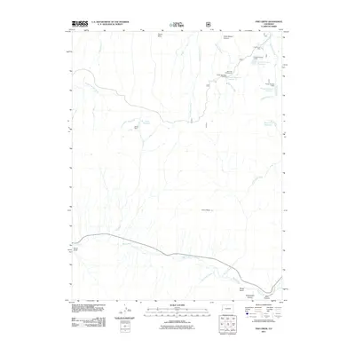
2011 Map of Fish Creek
USGS Topo · Published 2011About this map
Pinon Mesa and Payne Mesa define the high terrain of this Colorado landscape, where water management is central to the local geography. A series of reservoirs, including Fruita Reservoir Number 1, Fruita Reservoir Number 2, and Fruita Reservoir Number 3, are clustered in the northeast, managed by dams like Fruita Number 2 Dam. The drainage pattern is complex, with the Little Dolores River flowing north while the southern portion of the map is dominated by West Creek and its various tributaries. This 2011 survey by the U.S. Geological Survey shows a largely undeveloped area utilized for recreation and water storage, evidenced by the Hay Press Campground and Fruita Picnic Area. The map records several named topographic features such as Yellowjacket Canyon and Bear Canyon, providing a precise record of the mesas and canyons in this part of Mesa County.
Find a feature on this map
31 named features on this map. Tap any name to fly to it.
Don’t see what you’re looking for? This feature index may not catch every label — zoom into the map to look around manually.
Map Details
Editions of this 2011 Fish Creek Map
This is the sole edition of this map. No revisions or reprints were ever made.
Other maps of this area

1949 · Gateway
USGS Topo · 1:24,000

1950 · Pine Mountain
USGS Topo · 1:24,000

1952 · Gateway
USGS Topo · 1:24,000

1956 · Moab
USGS Topo · 1:250,000

1959 · Moab
USGS Topo · 1:250,000

1960 · Moab
USGS Topo · 1:250,000
1960 · Gateway
USGS Topo · 1:62,500
1960 · Gateway
USGS Topo · 1:24,000
1960 · Pine Mountain
USGS Topo · 1:24,000

1962 · Moab
USGS Topo · 1:250,000