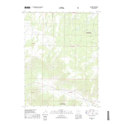
2019 Map of Fish Creek
USGS Topo · Published 2019About this map
Grand Mesa National Forest and Uncompahgre National Forest dominate this landscape on the western edge of Colorado. This region is defined by its complex water management infrastructure, most notably a string of elevated basins including Fruita Reservoir Number 1, Number 2, and Number 3. These reservoirs, along with smaller catchments like Burg Reservoir and Black Pine Reservoir, suggest a reliance on high-altitude water storage for the surrounding ranching or municipal needs.
Find a feature on this map
34 named features on this map. Tap any name to fly to it.
Don’t see what you’re looking for? This feature index may not catch every label — zoom into the map to look around manually.
Map Details
Editions of this 2019 Fish Creek Map
This is the sole edition of this map. No revisions or reprints were ever made.
Other maps of this area

1949 · Gateway
USGS Topo · 1:24,000

1950 · Pine Mountain
USGS Topo · 1:24,000

1952 · Gateway
USGS Topo · 1:24,000

1956 · Moab
USGS Topo · 1:250,000

1959 · Moab
USGS Topo · 1:250,000

1960 · Moab
USGS Topo · 1:250,000
1960 · Gateway
USGS Topo · 1:62,500
1960 · Gateway
USGS Topo · 1:24,000
1960 · Pine Mountain
USGS Topo · 1:24,000

1962 · Moab
USGS Topo · 1:250,000