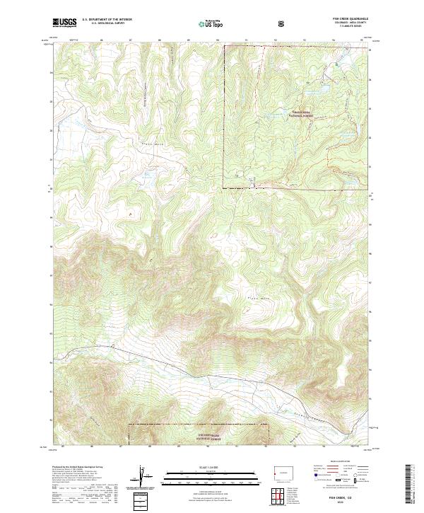
2022 Map of Fish Creek
USGS Topo · Published 2022About this map
Piñon Mesa dominates this 2022 survey of high-elevation Mesa County, characterized by a complex network of canyons and upland water management systems. The map details the boundary between Grand Mesa National Forest and Uncompahgre National Forest, showcasing a landscape where drainage from Hay Press Cr and the Little Dolores River is captured in high-altitude impoundments like Fruita Reservoir Number One and Fruita Reservoir Number Two. In the south, the terrain drops sharply into the dramatic Unaweep Canyon, with steep drainages including Pansy Gulch and Turner Gulch feeding into W Cr. This modern topographic study preserves the naming of specific geological features and rural access routes like Turkey Flats Trl and Ridge Trl, reflecting the region's ongoing importance for forest management and water resources.
Find a feature on this map
36 named features on this map. Tap any name to fly to it.
Don’t see what you’re looking for? This feature index may not catch every label — zoom into the map to look around manually.
Map Details
Editions of this 2022 Fish Creek Map
This is the sole edition of this map. No revisions or reprints were ever made.
Other maps of this area

1949 · Gateway
USGS Topo · 1:24,000

1950 · Pine Mountain
USGS Topo · 1:24,000

1952 · Gateway
USGS Topo · 1:24,000

1956 · Moab
USGS Topo · 1:250,000

1959 · Moab
USGS Topo · 1:250,000

1960 · Moab
USGS Topo · 1:250,000
1960 · Gateway
USGS Topo · 1:62,500
1960 · Gateway
USGS Topo · 1:24,000
1960 · Pine Mountain
USGS Topo · 1:24,000

1962 · Moab
USGS Topo · 1:250,000