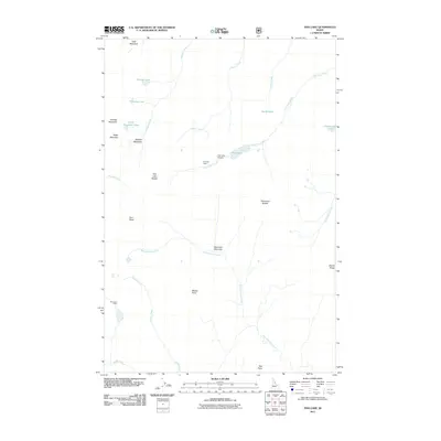
2011 Map of Fish Lake
USGS Topo · Published 2011About this map
Fish Lake and its high-elevation backcountry define this Idaho landscape, where human presence is marked only by isolated outposts and remote infrastructure. The Fish Lake Cabin and the nearby Fish Lake Airport serve as central points in a wilderness area dominated by complex hydrology and named peaks. To the north, Gold Meadows and Sponge Meadows provide open terrain amidst a network of small alpine water bodies including Sponge Lake, Pollywog Lake, and Heslip Lake. Movement through the area relies on natural corridors like Fish Lake Saddle and Tribulation Saddle. The drainage patterns are distinct, with Wounded Doe Creek and Grotto Creek carving through the southern reaches near Rhoda Point, while Barren Ridge stands as a prominent boundary to the east.
Find a feature on this map
29 named features on this map. Tap any name to fly to it.
Don’t see what you’re looking for? This feature index may not catch every label — zoom into the map to look around manually.
Map Details
Editions of this 2011 Fish Lake Map
This is the sole edition of this map. No revisions or reprints were ever made.
Other maps of this area

1911 · Lolo
USGS Topo · 1:250,000

1913 · Lolo
USGS Topo · 1:250,000

1956 · Hamilton
USGS Topo · 1:250,000

1959 · Hamilton
USGS Topo · 1:250,000

1960 · Hamilton
USGS Topo · 1:250,000

1964 · Hamilton
USGS Topo · 1:250,000

1966 · Mc Connell Mtn
USGS Topo · 1:24,000
1966 · Big Rock Mtn
USGS Topo · 1:24,000
1966 · Shissler Peak
USGS Topo · 1:24,000
1966 · Fenn Mountain
USGS Topo · 1:24,000