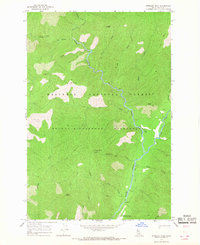
1966 Map of Shissler Peak
USGS Topo · Published 1968About this map
Shissler Peak rises as a central landmark within this mid-1960s survey of the Selway-Bitterroot Wilderness, where the landscape is defined by the confluence of the North Fork and Moose Creek. The absence of established land lines or roads highlights the area's primitive character, preserved within the Nez Perce National Forest. Human presence is concentrated around the Moose Creek Ranger Station, which is supported by a remote Landing Strip and a network of Pack Trails used for backcountry navigation. High-altitude points such as Shasta Point, Goat Mountain, and Cone Peak surround the river valleys, while a Lookout Tower on Shissler Peak suggests the vital role of fire observation in this heavily timbered region. Numerous drainages including Whistling Pig Creek and Rhoda Creek flow through deep ridges like Sixtytwo Ridge, illustrating the complex drainage system feeding the larger forks of the Moose Creek watershed.
Find a feature on this map
27 named features on this map. Tap any name to fly to it.
Don’t see what you’re looking for? This feature index may not catch every label — zoom into the map to look around manually.
Map Details
Editions of this 1966 Shissler Peak Map
2 editions found
Other maps of this area

1911 · Lolo
USGS Topo · 1:250,000

1913 · Lolo
USGS Topo · 1:250,000

1956 · Hamilton
USGS Topo · 1:250,000

1959 · Hamilton
USGS Topo · 1:250,000

1960 · Hamilton
USGS Topo · 1:250,000

1964 · Hamilton
USGS Topo · 1:250,000

1966 · Mc Connell Mtn
USGS Topo · 1:24,000

1966 · Moose Ridge
USGS Topo · 1:24,000

1966 · Dog Creek
USGS Topo · 1:24,000
1966 · Big Rock Mtn
USGS Topo · 1:24,000