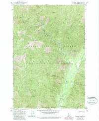
1966 Map of Shissler Peak
USGS Topo · Published 1987About this map
Nezperce National Forest terrain dominates this mid-1960s survey, defined by the confluence of the North Fork and East Fork rivers. The high-altitude topography is anchored by Shissler Peak Lookout Tower, overlooking a landscape carved by Moose Creek and Log Creek. Human presence is sparse and specialized, concentrated at the Moose Creek Ranger Station and the nearby Landing Strip, which served as critical access points for this interior portion of the Selway-Bitterroot Wilderness. The map captures the remote character of the Middle Fork Clearwater Wild and Scenic River corridor during a period of forest management and wilderness preservation. Notable landmarks like Freeman Place and Graves appear alongside extensive Pack Trail networks that follow ridges like Log Ridge, tracing the only established routes through the steep drainage systems of the Idaho backcountry.
Find a feature on this map
31 named features on this map. Tap any name to fly to it.
Don’t see what you’re looking for? This feature index may not catch every label — zoom into the map to look around manually.
Map Details
Editions of this 1966 Shissler Peak Map
2 editions found
Other maps of this area

1911 · Lolo
USGS Topo · 1:250,000

1913 · Lolo
USGS Topo · 1:250,000

1956 · Hamilton
USGS Topo · 1:250,000

1959 · Hamilton
USGS Topo · 1:250,000

1960 · Hamilton
USGS Topo · 1:250,000

1964 · Hamilton
USGS Topo · 1:250,000

1966 · Mc Connell Mtn
USGS Topo · 1:24,000

1966 · Moose Ridge
USGS Topo · 1:24,000

1966 · Dog Creek
USGS Topo · 1:24,000
1966 · Big Rock Mtn
USGS Topo · 1:24,000