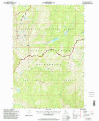
1995 Map of Fish Lake
USGS Topo · Published 1999About this map
Fish Lake and its surrounding high-country terrain define this mid-1990s survey of the Idaho backcountry. The landscape is dominated by the intersecting boundaries of the Clearwater National Forest, Nez Perce National Forest, and the Selway Bitterroot Wilderness. A distinct human imprint is visible at the Fish Lake Airstrip and the nearby Fish Lake Cabin, which serve as isolated points of access in a region otherwise characterized by peaks and creek drainages.
Find a feature on this map
38 named features on this map. Tap any name to fly to it.
Don’t see what you’re looking for? This feature index may not catch every label — zoom into the map to look around manually.
Map Details
Editions of this 1995 Fish Lake Map
This is the sole edition of this map. No revisions or reprints were ever made.
Other maps of this area

1911 · Lolo
USGS Topo · 1:250,000

1913 · Lolo
USGS Topo · 1:250,000

1956 · Hamilton
USGS Topo · 1:250,000

1959 · Hamilton
USGS Topo · 1:250,000

1960 · Hamilton
USGS Topo · 1:250,000

1964 · Hamilton
USGS Topo · 1:250,000

1966 · Mc Connell Mtn
USGS Topo · 1:24,000
1966 · Big Rock Mtn
USGS Topo · 1:24,000
1966 · Shissler Peak
USGS Topo · 1:24,000
1966 · Fenn Mountain
USGS Topo · 1:24,000