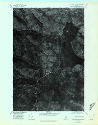
1975 Map of Fish River Lake SE
USGS Topo · Published 1981About this map
Fish Lake and its surrounding Maine timberlands are captured in this mid-1970s orthophotoquad, which uses aerial imagery to show the actual texture of the forest and waterways. The northern reach of Fish River dominates the eastern half of the sheet, winding southward from the lake through a landscape defined by drainage patterns like Chase Brook and Fox Brook. To the south, Mud Pond sits in a low-lying basin, illustrating the complex hydrology of this part of Aroostook County. The orthophotographic format provides a distinct view of the logging roads and clearing patterns of the era, offering researchers a realistic look at the land cover and environmental conditions before more modern development or reforestation changed the forest's footprint.
Find a feature on this map
5 named features on this map. Tap any name to fly to it.
Don’t see what you’re looking for? This feature index may not catch every label — zoom into the map to look around manually.
Map Details
Editions of this 1975 Fish River Lake SE Map
This is the sole edition of this map. No revisions or reprints were ever made.
Other maps of this area

1928 · Winterville
USGS Topo · 1:48,000

1930 · Greenlaw
USGS Topo · 1:48,000

1931 · Fish River Lake
USGS Topo · 1:48,000

1931 · Mooseleuk Lake
USGS Topo · 1:48,000

1931 · Winterville
USGS Topo · 1:62,500

1933 · Greenlaw
USGS Topo · 1:62,500

1935 · Fish River Lake
USGS Topo · 1:62,500

1935 · Mooseleuk Lake
USGS Topo · 1:62,500

1954 · Presque Isle
USGS Topo · 1:250,000

1958 · Presque Isle
USGS Topo · 1:250,000