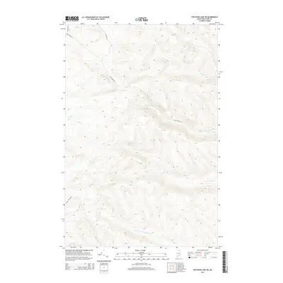
2014 Map of Fish River Lake SW
USGS Topo · Published 2014About this map
Mud Pond sits at the heart of this high-elevation landscape in the Aroostook County woods, marking a drainage divide where numerous streams originate. The terrain is defined by a dense network of headwaters including Smith Brook and Big Brook, which carve through the undulating topography. In the southern portion of the quadrangle, the Right Fork Twentymile Brook flows through deep valleys, complemented by the symmetrical reaches of N Br Fox Brook and S Br Fox Brook. Access to this remote timberland is provided by a few primitive routes such as Rocky Brook Rd and St Francis Rd, reflecting the area's primary use for forestry. The map reveals the intricate natural drainage patterns and the isolated nature of these northern Maine townships before they reach the larger river systems.
Find a feature on this map
9 named features on this map. Tap any name to fly to it.
Don’t see what you’re looking for? This feature index may not catch every label — zoom into the map to look around manually.
Map Details
Editions of this 2014 Fish River Lake SW Map
This is the sole edition of this map. No revisions or reprints were ever made.
Other maps of this area

1931 · Fish River Lake
USGS Topo · 1:48,000

1931 · Mooseleuk Lake
USGS Topo · 1:48,000

1932 · Musquacook Lakes
USGS Topo · 1:48,000

1932 · Allagash Falls
USGS Topo · 1:48,000

1935 · Musquacook Lakes
USGS Topo · 1:62,500

1935 · Fish River Lake
USGS Topo · 1:62,500

1935 · Mooseleuk Lake
USGS Topo · 1:62,500

1935 · Allagash Falls
USGS Topo · 1:62,500

1954 · Presque Isle
USGS Topo · 1:250,000

1956 · Allagash Falls
USGS Topo · 1:50,000