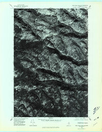
1975 Map of Fish River Lake SW
USGS Topo · Published 1981About this map
The North Branch Fox Brook and South Branch Fox Brook define the drainage of this unpopulated timberland in the Maine woods. This orthophotoquad, captured by the Geological Survey during a flyover in late 1975, reveals the complex texture of the forest floor and the heavy network of logging roads that crisscross the terrain between these two water bodies. Unlike traditional topographic maps, this imagery provides a direct view of the clear-cuts, thickets, and vegetation patterns at a 1:24,000 scale. The lack of named settlements or structures underscores the isolation of this interior region of Maine, where industrial forestry and natural watercourses like the Fox Brook branches are the primary features of the landscape.
Find a feature on this map
2 named features on this map. Tap any name to fly to it.
Don’t see what you’re looking for? This feature index may not catch every label — zoom into the map to look around manually.
Map Details
Editions of this 1975 Fish River Lake SW Map
This is the sole edition of this map. No revisions or reprints were ever made.
Other maps of this area

1931 · Fish River Lake
USGS Topo · 1:48,000

1931 · Mooseleuk Lake
USGS Topo · 1:48,000

1932 · Musquacook Lakes
USGS Topo · 1:48,000

1932 · Allagash Falls
USGS Topo · 1:48,000

1935 · Musquacook Lakes
USGS Topo · 1:62,500

1935 · Fish River Lake
USGS Topo · 1:62,500

1935 · Mooseleuk Lake
USGS Topo · 1:62,500

1935 · Allagash Falls
USGS Topo · 1:62,500

1954 · Presque Isle
USGS Topo · 1:250,000

1956 · Allagash Falls
USGS Topo · 1:50,000