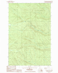
1985 Map of Fish River Lake SW
USGS Topo · Published 1986About this map
Mud Pond sits at the hydrological center of this remote North Maine Woods township map, surrounded by a complex system of feeder streams and timber access routes. The landscape is defined by the headwaters of several drainages, including the eastward-flowing North Branch Fox Brook and South Branch Fox Brook. This survey captures the region during a period of active resource management, evidenced by the scattered Gravel Pits used for road maintenance and the network of unimproved trails and private roads connecting T 14 R 10 Wels and T 13 R 9 Wels. The map reveals the intricate natural topography of the Fish River Lake area, where the Right Fork joins Twentymile Brook in the southern sector. Unlike more settled regions, this area is characterized by its township and range survey designations rather than incorporated towns, preserving a specific record of the state's deep wilderness character in the mid-1980s.
Find a feature on this map
15 named features on this map. Tap any name to fly to it.
Don’t see what you’re looking for? This feature index may not catch every label — zoom into the map to look around manually.
Map Details
Editions of this 1985 Fish River Lake SW Map
This is the sole edition of this map. No revisions or reprints were ever made.
Other maps of this area

1931 · Fish River Lake
USGS Topo · 1:48,000

1931 · Mooseleuk Lake
USGS Topo · 1:48,000

1932 · Musquacook Lakes
USGS Topo · 1:48,000

1932 · Allagash Falls
USGS Topo · 1:48,000

1935 · Musquacook Lakes
USGS Topo · 1:62,500

1935 · Fish River Lake
USGS Topo · 1:62,500

1935 · Mooseleuk Lake
USGS Topo · 1:62,500

1935 · Allagash Falls
USGS Topo · 1:62,500

1954 · Presque Isle
USGS Topo · 1:250,000

1956 · Allagash Falls
USGS Topo · 1:50,000