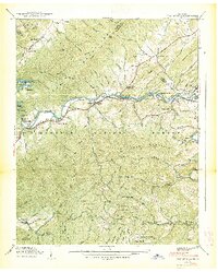
1938 Map of Fish Springs
USGS Topo · Published 1938About this map
The Watauga River corridor serves as the primary artery of development in this pre-war survey of northeastern Tennessee. The Southern Railway follows the river's winding path through the Iron Mountains, connecting riverside settlements like Fish Springs and Butler. This era of the landscape is defined by its small-scale communal infrastructure, featuring numerous rural educational and religious sites such as Cobb Creek Sch, Piercetown Sch, and Campbell Chapel. Near the western edge, the presence of Wilbur Lake and Wilbur Falls indicates early hydroelectric interests, while the surrounding Cherokee National Forest and high peaks like Gipson Mountain and Pond Mountain reflect the transition from agricultural bottomlands to protected wilderness. The map captures the original location of Butler and neighboring hamlets before later 20th-century water management projects altered the valley's geography.
Find a feature on this map
114 named features on this map. Tap any name to fly to it.
Don’t see what you’re looking for? This feature index may not catch every label — zoom into the map to look around manually.
Map Details
Editions of this 1938 Fish Springs Map
2 editions found
Other maps of this area

1891 · Roan Mountain
USGS Topo · 1:125,000

1893 · Cranberry
USGS Topo · 1:125,000

1894 · Roan Mountain
USGS Topo · 1:125,000

1895 · Cranberry
USGS Topo · 1:125,000

1899 · Cranberry
USGS Topo · 1:125,000

1902 · Cranberry
USGS Topo · 1:125,000

1904 · Roan Mountain
USGS Topo · 1:125,000

1934 · White Rocks Mtn
USGS Topo · 1:24,000

1934 · Iron Mtn Gap
USGS Topo · 1:24,000

1934 · Elk Park
USGS Topo · 1:24,000