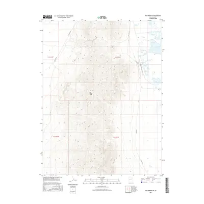
2017 Map of Fish Springs SW
USGS Topo · Published 2017About this map
The Fish Springs Range dominates this landscape in the eastern Great Basin, where sharp topographic relief meets the expansive Fish Springs Flat. This 2017 survey documents a desert environment defined by a critical network of water sources and historical transit corridors. The eastern edge of the range is punctuated by a cluster of vital desert springs, including House Springs, Thomas Springs, and Mirror Spring, which feed managed wetland areas like Mallard Pool and Shoveler Pool. Historical travel is etched into the terrain via the Pony Express Rd and Pony Express Pass Trl, tracing the path of the short-lived 1860s mail service. Modern access is represented by Sand Pass Rd and Harrison Pool Loop Rte 106, which navigate the margin between the steep mountain slopes and the marshy valley floor.
Find a feature on this map
23 named features on this map. Tap any name to fly to it.
Don’t see what you’re looking for? This feature index may not catch every label — zoom into the map to look around manually.
Map Details
Editions of this 2017 Fish Springs SW Map
This is the sole edition of this map. No revisions or reprints were ever made.
Other maps of this area

1908 · Fish Springs
USGS Topo · 1:250,000

1910 · Fish Springs
USGS Topo · 1:250,000

1953 · Delta
USGS Topo · 1:250,000

1958 · Delta
USGS Topo · 1:250,000

1960 · Granite Mountain
USGS Topo · 1:62,500

1962 · Delta
USGS Topo · 1:250,000

1967 · Sand Pass NW
USGS Topo · 1:24,000

1967 · Fish Springs NW
USGS Topo · 1:24,000

1967 · Fish Springs SE
USGS Topo · 1:24,000
1967 · Sand Pass NE
USGS Topo · 1:24,000