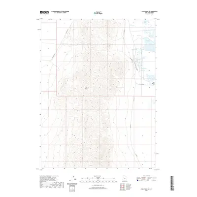
2020 Map of Fish Springs SW
USGS Topo · Published 2020About this map
Fish Springs Range dominates this landscape in Juab County, Utah, providing a high-elevation contrast to the low-lying Fish Springs Flat to the east. The map details a unique desert hydrologic system where numerous springs emerge at the base of the mountains, feeding a series of named wetlands and pools. Water sources such as Walter Spring, Thomas Spring, and House Springs support the surrounding pools, including Pintail Pool and Shoveler Pool. Historical transportation routes are prominent, most notably the Pony Express Rd, which skirts the northern and eastern edges of the range. The network of unpaved roads, including Sand Pass Rd and the Harrison Pool Loop Rte 106, underscores the area's remote character and its continuing role as a managed habitat for migratory birds and local wildlife.
Find a feature on this map
19 named features on this map. Tap any name to fly to it.
Don’t see what you’re looking for? This feature index may not catch every label — zoom into the map to look around manually.
Map Details
Editions of this 2020 Fish Springs SW Map
This is the sole edition of this map. No revisions or reprints were ever made.
Other maps of this area

1908 · Fish Springs
USGS Topo · 1:250,000

1910 · Fish Springs
USGS Topo · 1:250,000

1953 · Delta
USGS Topo · 1:250,000

1958 · Delta
USGS Topo · 1:250,000

1960 · Granite Mountain
USGS Topo · 1:62,500

1962 · Delta
USGS Topo · 1:250,000

1967 · Sand Pass NW
USGS Topo · 1:24,000

1967 · Fish Springs NW
USGS Topo · 1:24,000

1967 · Fish Springs SE
USGS Topo · 1:24,000
1967 · Sand Pass NE
USGS Topo · 1:24,000