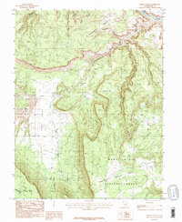
1985 Map of Fisher Valley
USGS Topo · Published 1986About this map
Fisher Valley and the surrounding high plateaus of Grand County characterize this mid-1980s landscape, defined by a complex network of canyons and high mesas. The northeastern corner of the map is dominated by the Dolores River as it cuts through the terrain, while the southern section transitions into the protected lands of the Manti-La Sal North National Forest. The map reveals a history of resource extraction, particularly on Polar Mesa, which is marked with numerous Adits, Mine Shafts, and mining prospects. Other significant relief features include Sevenmile Mesa and Beaver Mesa, separated by deep drainages like Thompson Canyon and Hideout Canyon. This survey captures the region's character as a site of both natural preservation and industrial activity during the later twentieth century.
Find a feature on this map
23 named features on this map. Tap any name to fly to it.
Don’t see what you’re looking for? This feature index may not catch every label — zoom into the map to look around manually.
Map Details
Editions of this 1985 Fisher Valley Map
This is the sole edition of this map. No revisions or reprints were ever made.
Other maps of this area

1885 · La Sal
USGS Topo · 1:250,000

1954 · Mt. Waas 4 SE
USGS Topo · 1:24,000

1954 · Mt. Waas 4 SW
USGS Topo · 1:24,000

1954 · Mt. Waas 4 NE
USGS Topo · 1:24,000

1954 · Mt. Waas 4 NW
USGS Topo · 1:24,000

1954 · Mt. Waas 3 NE
USGS Topo · 1:24,000

1954 · Mt. Waas 3 SE
USGS Topo · 1:24,000

1954 · Mt. Waas 1 SW
USGS Topo · 1:24,000

1954 · Mt. Waas 1 SE
USGS Topo · 1:24,000

1954 · Coates Creek
USGS Topo · 1:62,500