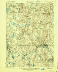
1935 Map of Fitchburg
USGS Topo · Published 1940About this map
The industrial hub of Fitchburg and the surrounding borderlands of Massachusetts and New Hampshire reveal a dense network of nineteenth-century infrastructure. This mid-1930s landscape is defined by its rail connectivity, centered on the Fitchburg Railroad and the Old Colony Railroad, which linked local mills and factories to broader regional markets. The terrain transitions from the concentrated urban centers of Fitchburg and Gardner to the high ridges of Watatic Mountain and New Ipswich Mtn in the north.
Find a feature on this map
147 named features on this map. Tap any name to fly to it.
Don’t see what you’re looking for? This feature index may not catch every label — zoom into the map to look around manually.
Map Details
Editions of this 1935 Fitchburg Map
3 editions found

Other maps of this area

1885 · Worcester
USGS Topo · 1:62,500

1886 · Worcester
USGS Topo · 1:62,500

1887 · Winchendon
USGS Topo · 1:62,500

1887 · Marlboro
USGS Topo · 1:62,500

1887 · Barre
USGS Topo · 1:62,500

1887 · Fitchburg
USGS Topo · 1:62,500

1889 · Marlboro
USGS Topo · 1:62,500

1889 · Fitchburg
USGS Topo · 1:62,500

1889 · Barre
USGS Topo · 1:62,500

1890 · Winchendon
USGS Topo · 1:62,500