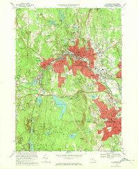
1969 Map of Fitchburg
USGS Topo · Published 1972About this map
Fitchburg and Leominster anchor this industrial and academic landscape, where the Penn Central and Boston and Maine railroads follow the path of the Whitman River and Phillips Brook. The urban center is defined by institutional landmarks like Fitchburg State College and the prominent Rollstone Hill quarry site. To the south and west, the terrain rises into the Leominster State Forest and the Fitchburg State Forest, areas marked by a complex network of municipal water supplies including Notown Reservoir, Haynes Reservoir, and Scott Reservoir. The map reveals the dense civic fabric of the era, from the concentration of neighborhood schools like Notre Dame High Sch to the expansive Cogshall Park and the Fitchburg Municipal Airport on the eastern edge of the quadrangle.
Find a feature on this map
119 named features on this map. Tap any name to fly to it.
Don’t see what you’re looking for? This feature index may not catch every label — zoom into the map to look around manually.
Map Details
Editions of this 1969 Fitchburg Map
2 editions found
Other maps of this area

1885 · Worcester
USGS Topo · 1:62,500

1886 · Worcester
USGS Topo · 1:62,500

1887 · Marlboro
USGS Topo · 1:62,500

1887 · Fitchburg
USGS Topo · 1:62,500

1889 · Marlboro
USGS Topo · 1:62,500

1889 · Fitchburg
USGS Topo · 1:62,500

1892 · Worcester
USGS Topo · 1:62,500

1893 · Fitchburg
USGS Topo · 1:62,500

1893 · Groton
USGS Topo · 1:62,500

1896 · Marlboro
USGS Topo · 1:62,500