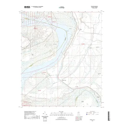
2020 Map of Fitler
USGS Topo · Published 2020About this map
Mississippi River shifts and sediment deposits define the landscape of the Louisiana and Mississippi border, where dynamic landforms like Fitler Bend and Newman Towhead dictate the river's course. This area of Issaquena County and East Carroll Parish is characterized by extensive wetlands and oxbow formations such as Concord Lake, Pumpkinseed Lake, and Goose Lake. The mapping of Albemarle Crevasse serves as a reminder of the river's historical power to breach levees and reshape the alluvial plain. Human presence is clustered along road networks like Fitler Rd and Levee Rd, connecting the settlements of Fitler, New Fitler, and Magna Vista. The presence of the Lookout Point Airport near Transylvania Chute indicates modern infrastructure situated within a terrain still heavily influenced by the seasonal ebb and flow of the Steele Bayou and Newsom Bayou systems.
Find a feature on this map
44 named features on this map. Tap any name to fly to it.
Don’t see what you’re looking for? This feature index may not catch every label — zoom into the map to look around manually.
Map Details
Editions of this 2020 Fitler Map
This is the sole edition of this map. No revisions or reprints were ever made.
Other maps of this area

1909 · Lake Providence
USGS Topo · 1:24,000

1911 · Lake Providence
USGS Topo · 1:31,680

1939 · Onward
USGS Topo · 1:62,500

1939 · Lorenzen
USGS Topo · 1:62,500

1939 · Alsatia
USGS Topo · 1:62,500

1939 · Mayersville
USGS Topo · 1:62,500

1955 · Jackson
USGS Topo · 1:250,000

1961 · Jackson
USGS Topo · 1:250,000

1962 · Jackson
USGS Topo · 1:250,000

1963 · Onward
USGS Topo · 1:62,500